Category Archives: Science

Fun with the sun part one – the Equation of Time

Sunset from Bryher
Sunset from Bryher

I guess pretty much all of us know that December 21st this year marked the winter solstice, and so – in the northern hemisphere – the shortest day and longest night of the year. But comparatively few people seem to know that this day is not the one when the sun rises latest and sets earliest. The exact dates of those events are, at the latitude of London, just over a week different from the solstice. Specifically, the latest sunrise this year is not until January 1st 2017, and the earliest sunset was on December 12th.

It turns out that the times when the sun rises and sets are governed by a moderately complicated algorithm called the Equation of Time. This obviously varies with your latitude and longitude, but also takes into account the small differences between the solar day and the sidereal day (the day length as measured against the distant and essentially fixed stars), seasonal variations in the earth’s distance from the sun, the apparent size of the solar disk, and a host of other relevant pieces of information. Strictly speaking, one’s height above sea level, and the details of the surrounding terrain also make a difference, but not in a way that’s easy to quantify here. Finally, there are several different definitions of what angle counts as the zenith line, and I have taken the civil definition as opposed to nautical or astronomical.

Once upon a time the calculations would have taken a very long time and lots of paper, but nowadays we can throw the calculation steps into Excel and find out the information for anywhere we want, and for a reasonably long span of time into the past or future. For the curious, a step by step description can be found at this link.

Sunrise through the year at different locations

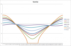
Out of curiosity, I plotted the changes for a series of latitudes from that of Reykjavik in Iceland (just over 64 degrees north) via Orkney, Penrith and London in the UK, through Rome and the Tropic of Cancer to the Equator. For simplicity I just took everything on the zero longitude line (through Greenwich) since I was only interested in changes in latitude. If you wanted to do this for yourself then you would need to adjust for your actual longitude east or west from Greenwich, and your official time zone.

Sunset through the year at different locations

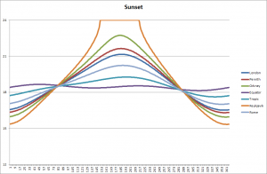
Here’s the corresponding chart for sunset.

A few things stand out at a quick glance. First, the time of sunrise varies considerably at some times of the year even between London and the north of Scotland. Secondly, you don’t have to go all that far north to get to the ‘land of the midnight sun‘. Thirdly, the total range of variation of sunrise is very small at the equator – about 1/2 an hour, as compared with London’s 4 1/2 hours, or Iceland’s 8 1/2 hours. The places where all these lines cross over is at the spring and autumn equinoxes, where night and day are each 12 hours long across the whole globe.

Sunrise - the early part of the year
Sunrise – the early part of the year

Going back to where we started, and looking carefully at the early part of the year, you can see that the day of latest sunrise happens after the solstice. The further north you go, the closer the two days are together. So in Reykjavik the latest sunrise is on December 26th. Come down to Orkney and it’s the 28th. In London you have to wait until January 1st. In Rome, January 5th. If you lived on the Tropic of Cancer (say in parts of the Sahara, roughly on a level with Kolkata, India) you’d be waiting for the 8th.

Changes through the year at the Equator

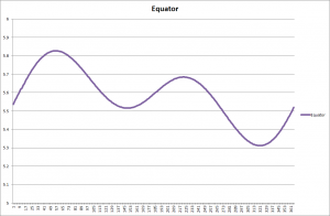
If you live right on the Equator something else comes into play. You get not just a simple days-get-longer then days-get-shorter cycle. Instead there is a more complex curve. Something similar happens in the whole belt of the tropics. This is because there are times when the sun at noon is to the south (as always happens in the northern hemisphere north of the Tropic of Cancer(, but then times when the noonday sun passes overhead and is, for a while, to the north. As it swings over and past you, the day length lengthens and then shortens again – as you can see in the graph.

OK, that’s enough of the Equation of Time for this week. Next time – another oddity about solar movements through the year, together with some thoughts about what this all means for us humans as we have observed the sun through the years. I am convinced that our remote ancestors knew about these patterns (though probably didn’t dress them up in the sines and cosines used by modern maths) and incorporated this knowledge into their monuments and observatories. But more of that next time…

Sunset from St Agnes

Recent Mars pics and news of a Kindle Countdown offer

Global mosaic taken by India's Mars Orbiter, http://www.isro.gov.in/
Global mosaic taken by India’s Mars Orbiter, http://www.isro.gov.in/

There have been some great pictures of Mars coming out recently from the Indian Mars Orbiter spacecraft so I thought I’d include a few here, together with an ESA video of a simulated flyby of one of the great valleys on Mars, the Mawrth Vallis.

Phobos in transit, from India's Mars Orbiter, http://www.isro.gov.in/
Phobos in transit, from India’s Mars Orbiter, http://www.isro.gov.in/

So here is Phobos, tiny against the curve of Mars and very close in its orbit. Most of chapter 2 of Timing takes place on this moon, partly at Asaph, a (hypothetical) settlement facing away from the planet. and partly at a sort of industrial estate in the Stickney crater facing inwards.

Olympus Mons from India's Mars Orbiter, http://www.isro.gov.in/
Olympus Mons from India’s Mars Orbiter, http://www.isro.gov.in/

And here is a three-d representation of Olympus Mons, the second highest mountain in the solar system. In the book, there’s a financial training college on the lower slopes of the mountain, roughly in the foreground as you are looking at the picture.

To celebrate all this I am running a science fiction Kindle Countdown offer right now – prices start at £0.99 / $0.99 and slowly increase to the normal price by next Monday. So don’t delay… Links are:

Timing

Far from the Spaceports

Finally, here’s the ESA video flyby of Mawrth Vallis. It’s one of the various places where – long ago – liquid water most likely ran and shaped the terrain we see. Now it is of course dry, but it’s a place that will be the focus of science at some point in the international effort to explore the red planet.


A history of water in fact and fiction

Cover image, The Martian Way, Goodreads

Many years ago I read a short science fiction story by Isaac Asimov called The Martian Way, which he published in 1952. In this, planet Earth maintained control over ambitious colonies elsewhere in the solar system by means of controlling the water supply. At the start of the story everyone assumed that Earth’s vast oceans were the only source of water available. Whoever controlled the water was in charge. The plot is resolved by the retrieval of a piece of Saturn’s rings the size of a small mountain, made largely of ice. With some modest engineering work this was propelled back to Mars where it was needed. The possibility of autocratic rule based on control of the necessities of life was gone.

Cover, Jules Verne Around the Moon, Wiki

It was a good story, and highlights our changing comprehension of the place of water in the universe at large. Go back only a century or two, and there was a widespread assumption that whatever other worlds might exist would be pretty much like Earth. Features on the Moon were called seas, bays, lakes and marshes, presuming that they held open water. Early science fiction writers like Jules Verne (From the Earth to the Moon and Around the Moon) and HG Wells (The War of the Worlds and The First Men in the Moon) took for granted that interplanetary travel would be relatively easy, and that once you landed, you would need no special protection except against low temperatures comparable to the Arctic. When in 1877 Italian astronomer Giovanni Schiaparelli named features on Mars canali (the Italian word for ‘channels’), nobody hesitated to use the English word canal.

Cover image, A Fall of Moondust, Goodreads

Then came the early days of space travel, along with a dramatic increase in the power and accuracy of telescopes. The lunar seas turned out to be open plains with no running water at all. The surface features on Mars ceased to be seen as artificial water channels, and were reinterpreted as the result of natural weathering on dry rock. The language we used for the planets changed. In 1961, Arthur C Clarke wrote A Fall of Moondust, where the plot hinged on the total absence of water. In 1969, Buzz Aldrin referred to the “Magnificent Desolation” that he saw on stepping out of the Apollo 11 lunar module. Imagery from the Apollo missions – and the personal accounts of astronauts – established the idea in the popular consciousness that the vivid blue of Earth’s oceans was something unique and precious in a starkly barren universe. The image was reinforced by the “Blue Dot” picture taken from the Voyager I probe.

Cover image, Encounter with Tiber, Goodreads

But after that, there was another wave of observations and information. Perhaps water was not so rare after all. The first target was the Moon, and a careful study of places which are permanently shadowed regions. It turned out that ice will tend to aggregate anywhere which is in shadow most of the time. Buzz Aldrin, turning to fiction in Encounter with Tiber, positioned an early lunar settlement at the Moon’s south pole, specifically because of this new-found source of water. The search for ice spread wider, and now it seems that pretty much everywhere we look we find it.

The asteroids have significant amounts scattered here and there, with some impressive finds by NASA’s Dawn probe. Mars itself shows every sign that open stretches of water once shaped the terrain, though accessing it nowadays might be tricky. As I was writing this, NASA reported the discovery of an underground body of ice just under the Martian surface. It seems that Asimov’s water-seeking Martian settlers would not have needed to trek out to Saturn after all. If they did go there anyway, they would find no mile-high ice mountains since the rings are largely made of tiny granules. However, several moons of both Jupiter and Saturn apparently have ice as their surface crust, and liquid water below.

Timing Kindle cover
Timing Kindle cover

So wherever we look in the solar system we find water, usually in the form of ice. Tomorrow’s space travellers and colonists will not have to worry about having access to water, though they will have to construct specialised equipment to access it. In Far from the Spaceports and Timing, my own fictional inhabitants of the Scilly Isles, somewhere out in the asteroid belt between Mars and Jupiter, will have to import many of life’s necessities, but not water – they will be able to find their own local supply.

Asimov wrote The Martian Way just as our scientific understanding was changing – indeed as with some other things he was ahead of his time. Although some of the details of his account would need updating, the basic theme remains sound. If and when we spread around the solar system, finding water is not going to be a problem.

Saturn's moon Prometheus and part of the ring system, NASA/JPL
Saturn’s moon Prometheus and part of the ring system, NASA/JPL

A busy week for space

There’s been a whole rush of space news these last few days, and what better place to gather some of it together than here? Most of it has some relevance to the Far from the Spaceports series…

Occator Crate, Ceres, taken as Dawn moves further out from the asteroid, NASA/JPL

The first item I saw was an update from the Dawn spacecraft, going through a series of changes to its orbit around Ceres. For a long time it was orbiting closer to the asteroid than the International Space Station is to Earth, less than 400km from the surface, and now it is returning to a much higher orbit to complete some science measurements from about 1500km. And as a treat we got back this picture of the Occator crater, one of the main locations for the bright white spots scattered here and there on the surface. More details can be found at the NASA site.

In between I read how Elon Musk is pushing ahead his plans for a privately funded settlement on Mars – the announcement was made back at the end of September but I had not previously followed the details through. His idea is ambitious, involving a fleet of reusable rockets working towards a colony of a million individuals, sent in groups of 1-200 at a time. More details can be found at several places including space.com. According to his figures, the price per individual will drop to around $1-200,000 – a lot of money, to be sure, but not unreachable. His current aim is to get an unmanned version sent on its way in about 18 months, and manned flights within a decade. We shall see…

Saturn's north pole, from Cassini, NASA/JPL
Saturn’s north pole, from Cassini, NASA/JPL

Then Cassini sent back this splendid picture of Saturn’s north pole. I was especially interested in that, since the planned book 3 following after Far from the Spaceports and Timing will include Saturn – or at least its moons – as a destination. Cassini has returned vast amounts of information about Saturn since 2004, but will run out of fuel late next summer and will be deliberately rerouted to burn up in Saturn’s atmosphere. This picture was taken at something like 1.4 mllion km from Saturn – 3 or 4 times the distance from the Earth to the Moon. More details can be found at the NASA site.

Finally a science article on a potential new form of spaceship engine has now been peer reviewed and published… Called the EmDrive, it was first worked on about 15 years ago by a British scientist, Roger Shawyer , and has now been taken up by NASA for serious study. The theoretical problem is that nobody has come up with a satisfactory explanation of how it could work: however several teams in the US and China have reported success, so maybe it’s going somewhere. Have a look at this link forthe latest news, or this link for some very sketchy details.

That’s all for today, but I’m sure there will be much more to come…

Timing Kindle cover
Timing cover
Far from the Spaceports cover

Thin slices of intelligence – meet the bot ‘Blakeley Raise’

Timing Kindle cover
Timing Kindle cover

The first part of this blog talks about background, so if you’re keen to read instead about my new chat-bot Blakeley Raise, just skip down a few paragraphs… I’m very excited about Blakeley Raise, and hope you’ll check out the new possibilities. If you can’t wait to give it a go, click here.

So, the background… I had the great pleasure of going to the technical day of the Microsoft  London Future Decoded conference last week. It was packed with all kinds of interesting stuff – far too much to take in in the course of a single day, in fact. There were cool presentations of 3d technology – the new Hololens device, enhanced ways to visualise 3d objects within a computer, and how 3d printing is shaking up some parts of the manufacturing industry. And lots of other stuff.

HAL 9000 from 2001 - A Space Odyssey (Wiki)
HAL 9000 from 2001 – A Space Odyssey (Wiki)

But it all threatened to be a bit overwhelming, so I kept my focus quite narrow and stayed mostly with the AI stream of presentations. Top level summary: Slate (in Far from the Spaceports and Timing) has no need to worry about the competition just yet, but there is some really interesting work going on. It will take a lot of generations for Slate to emerge! But the work that is being done is genuinely exciting, and a mixture of faster hardware, reliable communications, and good programming practice means that some tasks are now trickling into general everyday use.

One speaker used the phrase “slices of intelligence” to capture this, recognising that real intelligence involves not only a capacity to learn tasks and communicate visually and in words, but also to reflect on success and failure, set new challenges and move into new environments, interact with others, be aware of moral and ethical dimensions of an action, and so on. We are a very long way from producing artificial intelligence which can do most of that.

Blakeley Raise icon
Blakeley Raise icon

But within particular slices lots of progress has been made. Natural language parsing is now tolerably good rather than being merely laughable. Face recognition, including both identity and emotion, is reasonably accurate – though the site http://how-old.net/ produces such a vast range of potential ages from different pictures of the same person that one can be both flattered and disappointed very quickly (give it a try and you will soon find the limitations of the art at present). On a philanthropic note, image recognition software has been used to provide blind people with a commentary of interesting things in their immediate neighbourhood: see the YouTube snip at the end of this blog.

Kinninside Stone Circle at Blakeley Raise, Cumbria (Wiki)

Here’s the bit about Blakeley Raise… For those of us who develop our own software, it is an exciting time. It is extremely easy now to develop a small program called a chat-bot which can be incorporated not just into web pages, but also message applications like Skype, Facebook Messenger, and a host of others. So inspired by all this I have started developing Blakeley Raise, a bot who is designed to introduce potential readers to my books. You can think of Blakeley Raise as a great-great-ancestor of Slate herself, if you like, though I don’t think Slate will be feeling anxious about the competition for a long time yet.

But one of the great things about these bots is that they can be endlessly reconfigured and upgraded. Right now, Blakeley Raise just works by recognising keywords and responding accordingly. Type in “Tell me about Timing” – or another sentence containing the word “Timing” and you’ll get some information about that book. To find out more, navigate your browser to http://www.kephrath.com/trial/BlakeleyRaise.aspx and see what happens. All being well – meaning if I can solve a few technical problems – Blakeley Raise will soon appear on other distribution channels as well. (For those who remember the episode where a Microsoft bot quickly learned how to repeat racist and other inflammatory material, don’t worry – Blakeley Raise does not learn like that)

Finally, here’s a video of one of the more philanthropic spinoffs from Microsoft’s enthusiasm about AI in practical use…


A Matter of Perspective

Scilly Isles Chart (1689)

Today’s topic is – once again – inspired by an experience on the Scilly Isles. It has to do with how things look different from one point of view than they do from another. If you were going to navigate between the islands – say from Bryher round to St Martin’s – then the chances are you’d pull out a map. If you were feeling particularly cautious, or you were going in a larger boat which drew more water, maybe you’d go up a grade and get yourself a chart with underwater depths plotted. Coupled with some knowledge of the tide, you could then plot out a course.

Now if you also had a GPS navigation system, in principle you could then hand over the course to that, sit back, and enjoy the journey with no more effort. But if you didn’t have that, and you were reliant on personally converting all that map work into movements of the tiller, you’d find that it is rather more tricky than it looks.

Samson, Tresco. S Mary's, and rocks between
Samson, Tresco. S Mary’s, and rocks between

A map is a top-down view of the world – the sort of thing you would see if you were flying. But out on the water you get a completely different perspective. You are looking along the (reasonably) flat surface of the water, seeing the sides of islands and rocks as they project up from that surface. Some things – perhaps your destination – are hidden behind other ones. Some things which look close together are actually far apart, having been brought together by visual accident. A passage between two rocks might appear wide and easy on your chart, but narrow and problematic on the water, since it calls for careful wiggling at key moments.

Now, of course, this was the norm for navigation throughout our history until very recently, and goes a long way to explaining why the profession of pilot was so important. The pilot knew his waters, and how to navigate ships of different sizes through them at different states of the tide – or indeed not to make the attempt until the tide turned.

Now, maps and charts to help navigation have been around for quite a long time – several centuries, at least. But a pilot in action was not so interested in the top down view given by a chart. What he wanted – needed – to know was the direction to steer in at any point. And this was done, by and large, by means of lines of sight. Certainly pilots necessarily built up a vast store of information of local conditions in all kinds of weather and tide. But the key to their navigation was the index of knowledge which knew that by lining up particular landmarks one behind the other, and trusting these remote guidelines over local phenomena, a difficult voyage could be broken down into a series of simple legs.

Swallows and Amazons cover (Goodreads)

Each sight line gives you a stage in your journey: each journey consists of a chain of such guidelines. Arthur Ransome used this idea in Swallows and Amazons, where a navigation line was set up by visible marks in daytime, or lanterns after dark. John says: “This [stump marked with white cross] is one of the marks, and the other is that tree with a fork in it… come into the harbour without bothering about the rocks by keeping those two in line”. In this way they could easily get in and put of the harbour on Wildcat Island. The pilot’s job was basically the same, but upscaled to a much larger region and a hugely more complex set of navigation tasks.

Solar eclipse March 2016 (NASA)

But it is not just navigation on the water which has this difficulty. When we look up at the night sky, at stars and planets, we are looking at objects scattered through a vast three-dimensional space, as though they were arranged on the surface of a sphere. Extremely distant objects are pressed together, and small nearby ones can hide much larger further-away ones – as in this solar eclipse. And although changing tides are not a problem in space, things are moving at different speeds, and if you are trying to navigate – say – from one of Jupiter’s moons down to Mars, you have to take into account the change of location which will happen in the meantime. Human pilots still ply their trade in many parts of the world, and although they are usually supported by electronic backup, it still calls for in-depth familiarity with their coast, and day-by-day assessments of change. I wonder if the same will be true if and when we move into space?

The Bideford pilot boat (http://www.boatstories.co.uk/the-bideford-pilot.html)

Recent news from the asteroid belt and beyond

Today’s blog collates various recent pieces of news about the asteroid belt and outer planets.

The series of spiral orbits used to move down to the low survey orbit - the new manouvre will more or less invert this, NASA/JPL
The series of spiral orbits used to move down to the low survey orbit – the new manouvre will more or less invert this, NASA/JPL

First, Ceres. The Dawn spacecraft has recently fired up its main ion drive again, in order to raise its orbit up to nearly 1500km. For the last few months it has been in orbit at 385km, closer to Ceres than the ISS is to us here on  Earth. This low orbit has been great for studying surface features, but there is plenty of science to be done from higher up, not least because the final orientation of the orbit in relation to Ceres and the sun will be quite different than on initial approach – this time it will go over the poles. The polar orbit is ideal for searching for additional water supplies to complement the ice already found (both on the surface and also below it). So the change was made while there is still enough fuel for the ion drive to make this transfer. A difficult choice had to be made between this, or the possibliity of moving on to a third asteroid – since Dawn has already over-delivered on the original objectives, either would have been a remarkable achievement.

Ahuna Mons in simulated perspective, vertical scale exaggerated by factor of 2, NASA/JPL

One of the last news releases before the orbit shift was about ice volcanoes, and in particular the volcano Ahuna Mons. It is an unusual shape, with other strange features, and the most plausible explanation at the moment is that it is basically a water volcano, spitting out water from a base of salty mud. Careful measurements of the orbital path have shown that the interior also contains a lot of water ice, probably arranged in a concentric shell around a rocky core. The asteroid – properly speaking a dwarf planet – is rather less dense than Earth or our Moon, but has an interesting internal structure which, perhaps, can one day be investigated more closely. At the same time, some traces of a very thin atmosphere were found – vastly too little to survive on, but enough to shape some surface conditions and interfere with the flow of the solar wind.

Inside Occator Crater, showing the bright pattern of salts (mostly sodium carbonate), NASA/JPL

Other studies from low orbit include the bright patches first noticed on the original approach. The brightest of all of these are in Occator Crater, and closer inspection has shown a large group of irregular refletive areas. The most prevalent theory is that they are patches of salt, exposed on the surface by geological activity from inide the planet as well as meteor impact from outside.

What we don’t know, of course, is how far these features are typical of asteroids more generally. Would, for example, prospective visitors to my fictional Scilly Isle asteroids find similar phenomena? At this stage, we don’t know. Dawn has visited just two asteroids – Ceres and Vesta. They were chosen in part because they are different from each other in various ways, not least the amount of water ice available (Vesta is much drier). It seems unlikely that these two snapshots have exhausted all the variety that there is to see.

Insofar as I have thought about the origins of the setting for these stories (and most of my thinking has been on much more immediate background) it seems likely that the hypothetical Scilly Isle asteroids would have common ancestry. After all, they’re only a matter of a few tens of thousands of km apart, and it would be a wild coincidence if they had all come from different places. In passing, this makes for a curious parallel with the real islands off the Cornish coast, since many of the islands we enjoy as separate places today were aggregated into a single island within fairly recent history. Bryher and Tresco were united as recently as the late 16th century, and in the Bronze Age only St Agnes was separate of the inhabited islands.

The presence of water ice in most of the solar system has become apparent over the last few years, and I have assumed that water supply would not be a problem for settlers. So far as Ceres goes, that’s certainly true. Our understanding of the particular details of how the ice is distributed will no doubt continue to evolve.

Haulani Crater in enhanced colour, highlighting newer material in blue, NASA/JPL

Much the same applies to mineral deposits of all kinds. Fictional asteroidal Scilly is full of failed attempts to mine substances. Today’s science community is rather divided as to whether asteroid mining will ever be financially viable. There is little doubt that all kinds of extractable material is present there, but serious questions remain as to whether the concentration or total volume is sufficient to meet the costs. In the books, Mitnash and his friends can make a decent return out of extracting rare earth elements from distributed areas of space with a higher proportion of dust and small rubble, variously called shoals and reefs in keeping with the oceanic turns of phrase throughout. We don’t yet know if this is feasible. As with so much else, we will have to wait for further exploration. Dawn has shown that a great deal can be done with automated probes, and it would be nice to imagine a long-term plan to map much larger sections of the asteroid belt.

It’s appropriate to finish for today with a quick mention of Juno, orbiting Jupiter and starting to return impressive levels of information. Here’s a picture of Jupiter’s north pole, a sight impossible to see from Earth.

Jupiter's north polar region on August 27th, NASA/JPL
Jupiter’s north polar region on August 27th, NASA/JPL

Not long to wait for Timing now…

I was going to do another post in the series on British prehistoric monuments this week, but that’s not ready yet.

So instead I thought I’d post up the descriptive blurb for the forthcoming Timing. There’ll be more about this over the next month or two as release date approaches.

Mars (NASA/JPL)
Mars (NASA/JPL)

Timing is set approximately a year after Far from the Spaceports. Mitnash and Slate have stopped off at the Scilly Isles on their way back towards Earth from a rather dull short-term assignment on Callisto, one of the moons of Jupiter. While they are there they hear some news which changes their plans radically.

Timing takes our spacefaring duo from the Scilly Isles down to Mars and its larger moon Phobos, and then back again as they pursue a new arrival on the fraud scene.

Without more delay, here’s the blurb:

___
When quick wits and loyalty are put to the test

Mitnash and his AI companion Slate, coders and investigators of interplanetary fraud, are at work again in Timing, the sequel to Far from the Spaceports.

This time their travels take them from Jupiter to Mars, chasing a small-scale scam which seems a waste of their time. Then the case escalates dramatically into threats and extortion. Robin’s Rebels, a new player in the game, is determined to bring down the financial world, and Slate’s fellow AIs are the targets. Will Slate be the next victim?

The clues lead them back to the asteroid belt, and to their friends on the Scilly Isles. The next attack will be here, and Mitnash and Slate must put themselves in the line of fire. To solve the case, they need to team up with an old adversary – the only person this far from Earth who has the necessary skills to help them. But can they trust somebody who keeps their own agenda so well hidden?
____

The cover is currently in preparation, and I’ll be sharing that before too long.

Haulani Crater, on Ceres (NASA/JPL)

Sacred sites and alignment

I’ve been reading quite a lot recently about prehistoric sites in the British Isles in particular two short books by Aubrey Burley covering stone circles and henges (Prehistoric Astronomy and Ritual, and Prehistoric Henges)

A definition from an archaeology text book is:

“Henge: a type of ritual monument found only in the British Isles consisting of a circular area, anything from 150 to 1700 feet across, delimited by a ditch with the bank normally outside it”.

So I thought I’d add to my blog of a few weeks ago with some others through the rest of this summer. The research into these monuments is quite fascinating, especially the leaps and bounds in understanding their orientation which have been achieved in the last few decades. To cut a long story short, the main choices are between alignment with some nearby feature on the land, or some far away feature in the heavens.

Benachie's Mither Tap - https://aroundthehills.wordpress.com/
Benachie’s Mither Tap – https://aroundthehills.wordpress.com/

Local ground features include prominent hills or mountains, especially where their shape is unusual or striking. Several Scottish sites are oriented towards hills which look like breasts, and it is not hard to imagine a belief that these were visible signs of an Earth goddess. So when you’re looking at a site, the first thing to do is look out beyond it to the skyline.

Stonehenge sunset - Wiki
Stonehenge sunset – Wiki

Astronomical alignments include both sun and moon, typically at key calendar points such as midsummer, midwinter, or the equinoxes. Plus the cardinal compass points. The evidence suggests that earlier sites were often aligned with respect to the moon, and were subsequently adapted by a later generation to a solar orientation. More of this another day, but the point here is that we often need to think twice about sites. It is easy from to imagine that the site was put together as a single coherent whole. The historical reality may be of a series of changes over many years, with new settlers reusing and repurposing older places. Stonehenge is a particularly good example of this.

Our own appreciation of lunar alignments has grown dramatically in recent years. Even as a casual tourist, it is quite easy to work out where the sun will rise at the calendar festivals using nothing more complicated than a compass. It remains predictably the same every year, so even without a compass it does not take long to mark out the cycle.

Major Lunar Standstlll - http://www.absoluteaxarquia.com/nightsky/moon.html
Major Lunar Standstlll – http://www.absoluteaxarquia.com/nightsky/moon.html

However, the moon’s movement is considerably more complicated, varying over a cycle lasting about 18.6 years. This is primarily because of the complex relationship between the earth’s orbit round the sun, and the moon’s orbit round the earth. Also, because the solar 365 day cycle contains almost exactly 13 lunar 28 day months, the quarterly solar festivals cannot all mesh neatly with the same moon phase. It takes a long time of regular watching to spot the patterns, and be able to understand and predict where the moon will rise and set.

Minor Lunar Standstill - http://www.absoluteaxarquia.com/nightsky/moon.html
Minor Lunar Standstill – http://www.absoluteaxarquia.com/nightsky/moon.html

The key observations over this 18.6 year cycle are of the most extreme northerly and southerly limits of rising and setting, called the Major and Minor Lunar Standstill points. These vary from place to place, partly because of changing latitude and partly through the accidents of the terrain. At latitude 55°, not far north of the cluster of henges near Penrith, the rising point of the full moon varies in its cycle by 12.5° either side of the place where the sun rises – a big shift along the landscape as seen from the centre of a henge! Even if the basic pattern is known, each region must carry out its own observations of where the moon will rise and set at these stationary points. This is where the local and distant alignment issues interact with each other. If you have recognised the exact direction to look in, what more natural impulse is there than to place your circle where that direction lines up with a prominent hill or valley?

Moonrise at the Major Lunar Standstill at Chimney Rock, Colorado. as seen from the Great Pueblo - http://www.chimneyrockco.org/
Moonrise at the Major Lunar Standstill at Chimney Rock, Colorado. as seen from the Great Pueblo – http://www.chimneyrockco.org/

It’s worth mentioning here that although henges may be restricted to the British Isles, lunar alignments are not. All over the world people have found places where the 18.6 year cycle is shown off to good advantage.

The astronomy of the moon’s movements is now well understood, and over the last few decades has been applied to stone circles and henges. It is not an easy task, given the considerable damage done to sites over the years by natural wear and tear together with human acts such as ploughing over ditches and banks, or robbing stones for building work. But aerial photography has provided huge insights into layout no longer visible on the surface, and some careful archaeology has uncovered items placed in particular locations.

University of Massachusetts Sunwheel - http://www.umass.edu/sunwheel/pages/moonteaching.html
University of Massachusetts Sunwheel – http://www.umass.edu/sunwheel/pages/moonteaching.html

Astonishingly, given the difficulties of observation and long baseline required, our remote ancestors have showed themselves to be well aware of the intricacies of the moon’s movement, and able to codify it in their monuments. Often these key directions are pinpointed by buried items. While there may well have been some visible signal such as a banner, it seems that the real importance was a sacred one. Apparently it was important to signal to the invisible world that you knew these patterns. In the absence of written texts from this era, we can only speculate.

To close this blog post with a striking but only very loosely related picture, here is the first image of Jupiter and a few of its moons, sent back by NASA’S Juno probe…

Jupiter and moons from Juno - NASA/JPL
Jupiter and moons from Juno – NASA/JPL

Hacking, QA, and software bugs

Swordfish film - Wiki
Swordfish film – Wiki

A few weeks ago I wrote about software development and hacking, and this is a loose follow-up. The image of hackers presented in films – Swordfish is a fair example, or GoldenEye – is of rather scruffy individuals who type incredibly quickly with keyboard at arms length, undeterred by all kinds of enticing distractions around them.

But most often, a successful hack is the result of careful analysis into some existing code, and a good dollop of insight into what kinds of precautions developers forget to take. In that, it shares a great deal in common with my own trade of QA. Effective software testing is not really about repeating hundreds of test cases which regularly pass – there are automated ways of dong those – it’s about finding the odd situations where proper execution fails. This might be because some developer has copied and pasted the wrong code, but it’s much more often because some rare but important set of circumstances was overlooked.

Trojan horse illustration (Wiki)

Missing values, extra-long pieces of text, duplicate entries where only one was expected, dates in weird formats – all these and many more keep us QA folk in work. And problems can creep in during the whole life of a product, not just at the start, Every time some change is carried out to a piece of software, there is the risk of breaking some existing behaviour, or introducing some new vulnerability which can be exploited by somebody.

It has been said that a great many of these things persist through laziness. One particular hack exploit – “SQL injection” – has been around for something over 15 years, in essentially unchanged form. You would think that by now, defences would be so automatic that it would no longer be an issue. But it is, and systems still fall prey to a relatively simple trick. I have worked with a lot of different computer languages, and find that pretty much the same problems turn up in any of them. As computer languages get more sophisticated and more robust, we expect them to do more interesting and more complicated things,

Estimated cost of data breaches in Germany (Wiki)

QA and hacking are at different parts of a spectrum, and a fair proportion of hackery goes on specifically to help firms and charities find weaknesses in their own systems. The legal distinction of when an activity crosses a line has to do with intention of malice, though a number of governments take a much stricter line where there own systems are concerned.

What has this to do with fiction? Well, Mitnash and Slate spend a lot of their time tracking down and defending against hacking in the area of finance. Their added complication is that the physical locations they travel to are scattered all around the solar system, with journey times of weeks or months, and signal times of hours. It is interesting to think about how hacking – and the defence against it – might evolve in such a situation.

In Timing, due for release in the late summer or early autumn, they are first sent to Jupiter to resolve a minor issue. It doesn’t seem very interesting or important to them. But then a much larger and more serious matter intrudes. To their dismay, the hackers – malicious ones in this case – have designed a new form of attack which our two heroes don’t really understand. They need help, and aren’t very sure they can trust their new-found helper.

To finish with, I can’t resist adding one of NASA’s pieces of artwork concerning the Juno probe, now successfully in orbit around Jupiter. It’s a great achievement, and we can look forward to some great science emerging from it.

Juno at Jupiter - NASA/JPL
Juno at Jupiter – NASA/JPL